Map of France

Saint-Floxel photos


Find a town, a zip code,
a department, a region... in France
I like Map-France.com !


Saint-Floxel pictures


Here are the photos of the town of Saint-Floxel and nearby towns. Saint-Floxel is located in the department of Manche in the region of Basse-Normandie. You will find the satellite map of Saint-Floxel under these photos.

To see photos of nearby towns of Saint-Floxel, you can try the following links :
   - Photo of Ozeville (50310) : town located at 1.64 km
   - Photo of Montebourg (50310) : town located at 2.08 km
   - Photo of Joganville (50310) : town located at 2.35 km
   - Photo of Fontenay-sur-Mer (50310) : town located at 2.57 km
   - Photo of Éroudeville (50310) : town located at 3.20 km
   - Photo of Vaudreville (50310) : town located at 3.31 km
   - Photo of Émondeville (50310) : town located at 3.49 km
   - Photo of Écausseville (50310) : town located at 3.53 km
   - Photo of Lestre (50310) : town located at 4.17 km
   - Photo of Saint-Martin-d'Audouville (50310) : town located at 4.39 km
   - Photo of Azeville (50310) : town located at 4.42 km
   - Photo of Quinéville (50310) : town located at 4.55 km

 - photos of the department prefecture of Manche : photos of Saint-Lô
 - pictures of others cities of Manche : Manche


To see Saint-Floxel from the sky, here is the satellite map of the town of Saint-Floxel : Saint-Floxel map.

I like Saint-Floxel !


Photos of the town of Saint-Floxel

These photos taken near the town of Saint-Floxel can be shown in full screen clicking on the thumbnails. Photos are copyrighted by their owners.

German Weapons - Photo of Saint-Floxel
German Weapons

Sainte Mere Eglise - Photo of Saint-Floxel
Sainte Mere Eglise

Sainte-Mère-Église church with John Steele monument. 10-7-2022 - Photo of Saint-Floxel
Sainte-Mère-Église church with John Steele monument. 10-7-2022

Sainte-Mère-Église church with John Steele monument. 10-7-2022 - Photo of Saint-Floxel
Sainte-Mère-Église church with John Steele monument. 10-7-2022

M4A4 Sherman ‘U.S.A. 3069548’ “Channel Blues” - Photo of Saint-Floxel
M4A4 Sherman ‘U.S.A. 3069548’ “Channel Blues”

GMC CCKW 353 ‘U.S.A. W-4238667-S’ - Photo of Saint-Floxel
GMC CCKW 353 ‘U.S.A. W-4238667-S’

M4A4 Sherman ‘U.S.A. 3069548’ “Channel Blues” at Sainte-Mère-Église - Photo of Saint-Floxel
M4A4 Sherman ‘U.S.A. 3069548’ “Channel Blues” at Sainte-Mère-Église

90mm Gun M1 “The Nightmare” at the Airborne Museum, Sainte-Mère-Église - Photo of Saint-Floxel
90mm Gun M1 “The Nightmare” at the Airborne Museum, Sainte-Mère-Église

8.8cm Flak gun at the Airborne Museum, Sainte-Mère-Église - Photo of Saint-Floxel
8.8cm Flak gun at the Airborne Museum, Sainte-Mère-Église

Piper J.3C-65 Cub ‘624 / 39-D’ (really 43-30073 / D-ECIV) - Photo of Saint-Floxel
Piper J.3C-65 Cub ‘624 / 39-D’ (really 43-30073 / D-ECIV)

Piper J.3C-65 Cub ‘624 / 39-D’ (really 43-30073 / D-ECIV) - Photo of Saint-Floxel
Piper J.3C-65 Cub ‘624 / 39-D’ (really 43-30073 / D-ECIV)

Douglas C-47B-25-DK Skytrain ‘315510 / W7-F’ (really 44-76229) - Photo of Saint-Floxel
Douglas C-47B-25-DK Skytrain ‘315510 / W7-F’ (really 44-76229)

Loading scene with C-47A Skytrain ‘315159 / D8-Z’ “The Argonia” (really 42-100825) - Photo of Saint-Floxel
Loading scene with C-47A Skytrain ‘315159 / D8-Z’ “The Argonia” (really 42-100825)

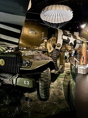
Douglas C-47A-70-DL Skytrain ‘315159 / D8-Z’ “The Argonia” (really 42-100825) - Photo of Saint-Floxel
Douglas C-47A-70-DL Skytrain ‘315159 / D8-Z’ “The Argonia” (really 42-100825)


Saint-Floxel from the sky


Old photos of the town of Saint-Floxel

These photos taken near the town of Saint-Floxel can be shown in full screen clicking on the thumbnails. Photos are copyrighted by their owners.


Other maps, hotels and towns in france


Find another town, zip code, department, region, ...


Quick links Saint-Floxel :


Back to the menus Map of France :


Make a link to this page of Saint-Floxel with the following code :


Map of France | Regions | Departments | Cities | Partners | Terms | Contact